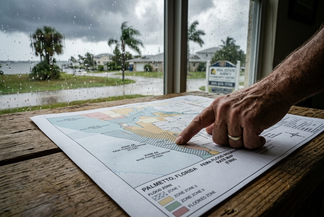
Interpreting Flood Maps
Just one inch of floodwater can cause thousands of dollars in damage to your home. In Florida, where heavy rainfall and hurricanes are regular occurrences, understanding flood zones and the maps that define them is crucial for safeguarding your property. These maps, provided by the Federal Emergency Management Agency (FEMA), help you determine whether your property sits in a high-risk zone (often requiring flood insurance) or a moderate-to-low risk zone.
Flood maps evolve over time due to weather patterns, new construction, and changes in topography. So even if you’re already familiar with your area’s flood risk, staying updated with the latest versions matters. Being informed helps you make smarter decisions about where to live, how to protect your property, and how much insurance coverage you actually need. Standard homeowners insurance doesn’t cover flood damage, which means specialized flood insurance can make all the difference when unexpected flooding hits. Understanding your flood zone is more than a precaution — knowing where you stand is a vital step in protecting both your home and your finances.
Interpreting Flood Maps
FEMA flood maps categorize areas into different flood zones, each indicating the likelihood of flooding in that region. For Florida residents, knowing how to read these maps can shape important decisions about purchasing or adjusting insurance policies.
When you look at a flood map, you’ll notice letters assigned to different zones. Letters like A, AE, AH, and VE each reflect a different level of flood risk. Zone A, for instance, carries a 1% annual chance of flooding, which is what’s commonly called the “100-year floodplain.” That means there’s a 1% chance of a significant flood in any given year.
In coastal areas like Palmetto, the VE zone deserves special attention. It represents areas at risk not only from flooding but from storm surges as well. These zones generally face stricter building codes because of the high risk of wave action during storms. Think of it this way: if Zone A is a serious flood risk, Zone VE is that risk with an added punch from the ocean.
Understanding these zones directly influences your flood insurance decisions. Flood insurance is mandatory for properties in high-risk zones if you carry a federally backed mortgage, but it’s also worth considering even in moderate to low-risk areas. Florida’s geography means that even properties outside designated high-risk zones can still be affected by heavy rains or overflowing rivers during hurricane season.
Another key factor is Base Flood Elevation (BFE), which indicates the expected height of floodwaters in a high-risk zone. Properties built below the BFE often carry higher insurance premiums because of the increased risk.
Flood maps are periodically updated to reflect new data and shifts in flood risk driven by environmental changes or updates in floodplain management practices. Keeping up with those changes in your local area ensures you stay adequately prepared and protected.
How Zones Affect Insurance
Flood zones play a significant role in determining the types and costs of flood insurance available to you. FEMA establishes these zones through detailed mapping, categorizing areas based on their flooding risk. For Florida residents, understanding that framework is especially important given the state’s exposure to heavy rains and hurricanes.
In Florida, flood zones are labeled A, B, C, D, V, and X. Zone A, and particularly AE, are high-risk areas with a 1% annual chance of flooding and a 26% chance over the life of a 30-year mortgage. If your home or business falls in one of these zones, your lender will likely require you to carry flood insurance. Zone V, found along Florida’s coastline, faces both flood and wave hazards and typically commands the highest insurance premiums because of that dual risk.
The zone your property sits in directly shapes the insurance policy you can choose. High-risk zones like A and V generally mean higher premiums since the potential for flood damage is greater. Living in a lower-risk zone like X often brings lower premiums and more flexibility in your coverage options. That said, premiums and requirements can vary widely depending on your specific location even within the same zone.
FEMA provides the foundational mapping, but insurers may also factor in local topography, urban drainage systems, and climate change projections. Each property carries its own unique risk profile, and coverage options can differ significantly from one parcel to the next, even on the same street.
Knowing the flood zone for your property gives you the footing to make informed decisions about insurance coverage. If you’re in Palmetto or anywhere else in Florida, keep an eye on map updates because changes can affect both what coverage you’re required to carry and what you’ll pay for it.
Using Maps for Safe Planning
Flood maps give you detailed, on-the-ground insight into which areas are prone to flooding, helping you make smarter decisions about property and safety before problems arise.
FEMA produces and updates these maps regularly, and each zone they identify carries a different level of risk. Zone A signals a higher flood risk, while Zone X is considered a minimal risk area. Having that information in hand lets you realistically assess your exposure and plan accordingly.
If you’re thinking about buying property in Palmetto or anywhere else in Florida, flood maps should be part of your due diligence. They help you figure out whether you’ll need additional flood insurance beyond a standard homeowners policy, which won’t cover flood damage on its own. In a state where hurricanes and heavy rains are part of life, that extra layer of protection can be the difference between recovering quickly and facing a financial crisis.
Flood maps are also essential when planning new construction. Understanding the risk in your area lets you incorporate flood-resistant features from the start. Consider elevation, drainage design, and water-resistant materials. Smart building decisions made early on can significantly reduce damage potential when severe weather rolls through.
Both homeowners and business owners should check the latest flood maps periodically. Palmetto, like much of Florida, may see updates reflecting new developments or natural landscape changes that shift flood risk over time. Staying current protects your peace of mind and keeps your coverage aligned with your actual exposure.
Beyond protecting individual properties, understanding flood maps supports broader community planning. Local governments rely on this data to plan infrastructure and coordinate emergency services. The Florida Division of Emergency Management provides state-specific resources on flood preparedness and risk. When residents stay informed about local flood risk, it contributes to safer, more resilient communities across Florida.
Frequently Asked Questions
1. How do flood maps indicate risk levels?
Flood maps are created by FEMA to show the flood risk across different areas. They divide the landscape into zones based on the likelihood of flooding in a given year. High-risk areas, known as Special Flood Hazard Areas (SFHAs), are marked as Zone A or Zone V. Moderate to low-risk areas are labeled as Zones B, C, or X. By looking at these zones, you can get a clear sense of how vulnerable your property is to flooding and use that knowledge to guide decisions about insurance and preparedness.
2. How does my zone affect my insurance premiums?
Your flood zone designation has a direct impact on what you’ll pay for flood insurance. Properties in high-risk zones like Zone A or Zone V typically face higher costs because the likelihood of flooding is greater. Properties in moderate to low-risk zones tend to carry lower premiums. Rates can still vary widely depending on your specific policy and carrier, so speaking with an insurance specialist can give you a much clearer picture of your options.
3. Can flood maps be used to plan new property investments?
Flood maps are valuable resources when evaluating a potential property purchase. They help you assess flood risk upfront, which factors directly into the true cost and long-term safety of any investment. For anyone considering a property in Palmetto or elsewhere in Florida, pairing flood map data with local real estate knowledge gives you a well-rounded view of both the risks and the opportunities. Tools like FloodSmart can also help you better understand your exposure and insurance options before making a decision.
Next Steps For You
Flood zones and the maps that define them are a fundamental part of life in Florida, especially where heavy rains and hurricanes come with the territory. These tools help you assess risk, make informed insurance decisions, and evaluate property investments with your eyes open. Flood insurance is a must in high-risk areas, but it’s a smart consideration even in lower-risk zones given how unpredictable Florida weather can be. Checking for map updates regularly keeps you ahead of any changes that could affect your coverage or your safety. The more you understand about your area’s flood risk, the better positioned you are to protect your home and support a more resilient community in places like Palmetto. To learn more about your coverage options, visit Anderson Insurance Group or contact us today.